
Saint-Laurent-du-Maroni topographic map
Interactive map
Click on the map to display elevation.
About this map
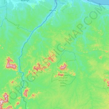
Name: Saint-Laurent-du-Maroni topographic map, elevation, terrain.
Location: Saint-Laurent-du-Maroni, French Guiana, 97320, France (4.27148 -54.28179 5.62315 -53.73902)
Average elevation: 83 m
Minimum elevation: -1 m
Maximum elevation: 669 m
Other topographic maps
Click on a map to view its topography, its elevation and its terrain.
ile aux Sept Chapelets
France > French Guiana > Régina
ile aux Sept Chapelets, Régina, Saint-Georges, French Guiana, France
Average elevation: 7 m
Mont Cépérou
France > French Guiana > Cayenne
Mont Cépérou, Cayenne, French Guiana, 97300, France
Average elevation: 2 m
Mont Édouard
France > French Guiana > Saül
Mont Édouard, Saül, Saint-Laurent-du-Maroni, French Guiana, 97314, France
Average elevation: 204 m
Kourou
France > French Guiana > Kourou
Kourou, Cayenne, French Guiana, 97310, France
Average elevation: 35 m
Mont Maunoir
France > French Guiana > Camopi
Mont Maunoir, Camopi, Cayenne, French Guiana, 97330, France
Average elevation: 136 m