
Sabadell topographic map
Interactive map
Click on the map to display elevation.
About this map
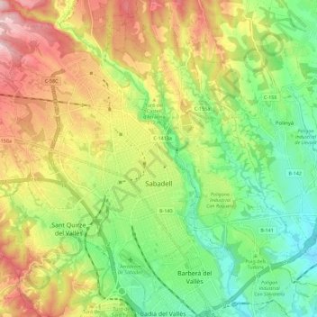
Name: Sabadell topographic map, elevation, terrain.
Location: Sabadell, Vallès Occidental, Barcelona, Catalonia, Spain (41.50657 2.04689 41.59055 2.15016)
Average elevation: 183 m
Minimum elevation: 69 m
Maximum elevation: 333 m
The city covers an area of 37.79 km2 (14.59 sq mi) and its population density is 5,337.57/km2 (13,824.2/sq mi) as of 2007. The altitude is 200 metres (660 ft).