
Canary Islands topographic map
Interactive map
Click on the map to display elevation.
About this map
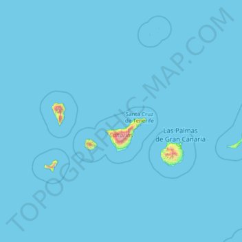
Name: Canary Islands topographic map, elevation, terrain.
Location: Canary Islands, Spain (27.63774 -18.16087 29.41606 -13.33201)
Average elevation: 16 m
Minimum elevation: 0 m
Maximum elevation: 3,500 m
The Canary Islands, especially Tenerife, Gran Canaria, Fuerteventura, and Lanzarote, are a major tourist destination, with over 12 million visitors per year. This is due to their beaches, subtropical climate, and important natural attractions, especially Maspalomas in Gran Canaria, Teide National Park, and Mount Teide (a World Heritage Site) in Tenerife. Mount Teide is the highest peak in Spain and the third tallest volcano in the world, measured from its base on the ocean floor. The islands have warm summers and winters warm enough for the climate to be technically tropical at sea level. The amount of precipitation and the level of maritime moderation vary depending on location and elevation. The archipelago includes green areas as well as desert areas. The islands' high mountains are ideal for astronomical observation, because they lie above the temperature inversion layer. As a result, the archipelago boasts two professional observatories: Teide Observatory on the island of Tenerife, and Roque de los Muchachos Observatory on the island of La Palma.
Other topographic maps
Click on a map to view its topography, its elevation and its terrain.
Playa Isla de Canela
Spain > Andalusia > Costa Occidental > Ayamonte
Playa Isla de Canela, Ayamonte, Costa Occidental, Huelva, Andalusia, 21409, Spain
Average elevation: 2 m
San Cristóbal de Segovia
San Cristóbal de Segovia, Segovia, Castile and León, 40197, Spain
Average elevation: 1,060 m
Las Vagas
Spain > Aragon > Cuencas Mineras > Martín del Río > La Rambla de Martín
Las Vagas, La Rambla de Martín, Martín del Río, Cuencas Mineras, Teruel, Aragon, Spain
Average elevation: 1,120 m
Ibarra
Spain > Autonomous Community of the Basque Country
Ibarra, Gipuzkoa, Autonomous Community of the Basque Country, 20400, Spain
Average elevation: 259 m
Presa Vieja de Las Navas del Marques
Spain > Castile and León > Peguerinos
Presa Vieja de Las Navas del Marques, Peguerinos, Ávila, Castile and León, Spain
Average elevation: 1,496 m
Las Navas
Spain > Andalusia > Priego de Córdoba
Las Navas, Priego de Córdoba, Córdoba, Andalusia, Spain
Average elevation: 926 m
Santiago de Compostela
Santiago de Compostela, Santiago, A Coruña, Galicia, Spain
Average elevation: 277 m
Talavera de la Reina
Talavera de la Reina, Castile-La Mancha, Spain
Average elevation: 453 m
Bidasoa Beherea / Bajo Bidasoa
Spain > Autonomous Community of the Basque Country
Bidasoa Beherea / Bajo Bidasoa, Gipuzkoa, Autonomous Community of the Basque Country, Spain
Average elevation: 111 m
San Agustín
Spain > Aragon > Gúdar-Javalambre
San Agustín, Gúdar-Javalambre, Teruel, Aragon, 44480, Spain
Average elevation: 919 m
Arrutiegia
Spain > Autonomous Community of the Basque Country > Urola-Kosta > Aia
Arrutiegia, Aia, Urola-Kosta, Gipuzkoa, Autonomous Community of the Basque Country, 20809, Spain
Average elevation: 223 m
Toroño
Spain > Castile and León > Porto
Toroño, Porto, Zamora, Castile and León, Spain
Average elevation: 1,495 m
Marbella
Spain > Andalusia > Costa del Sol Occidental
Marbella, Costa del Sol Occidental, Malaga, Andalusia, Spain
Average elevation: 216 m
Bizkaia
Spain > Pirinioak / Pirineo > Garde
Bizkaia, Garde, Pirinioak / Pirineo, Spain
Average elevation: 1,225 m
Ansoáin / Antsoain
Spain > Iruñerria / Comarca de Pamplona
Ansoáin / Antsoain, Ansoáin/Antsoain, Iruñerria / Comarca de Pamplona, Spain
Average elevation: 487 m
Olvera
Spain > Andalusia > Sierra de Cádiz
Olvera, Sierra de Cádiz, Cádiz, Andalusia, 11690, Spain
Average elevation: 519 m
Inca
Spain > Balearic Islands > Raiguer
Inca, Raiguer, Balearic Islands, 07300, Spain
Average elevation: 125 m
Peñafiel
Peñafiel, Valladolid, Castile and León, 47300, Spain
Average elevation: 824 m
San Isidro
Spain > Valencian Community > el Baix Segura / La Vega Baja del Segura
San Isidro, el Baix Segura / La Vega Baja del Segura, Alacant / Alicante, Valencian Community, Spain
Average elevation: 11 m
la Romana
la Romana, el Vinalopó Mitjà / El Vinalopó Medio, Alacant / Alicante, Valencian Community, 03669, Spain
Average elevation: 532 m
Las Catorce
Spain > Andalusia > Sierra de Cádiz > El Bosque
Las Catorce, El Bosque, Sierra de Cádiz, Cádiz, Andalusia, 11670, Spain
Average elevation: 364 m
Ayagaures
Spain > San Bartolomé de Tirajana
Ayagaures, San Bartolomé de Tirajana, Las Palmas, Canary Islands, 35290, Spain
Average elevation: 535 m
Urbanització Cala Llonga
Spain > Balearic Islands > Ibiza > Santa Eulària des Riu
Urbanització Cala Llonga, Santa Eulària des Riu, Ibiza, Balearic Islands, 07840, Spain
Average elevation: 39 m
Sabadell
Spain > Catalonia > Vallès Occidental
Sabadell, Vallès Occidental, Barcelona, Catalonia, Spain
Average elevation: 183 m
Valsain
Spain > Aragon > Campo de Daroca > Villarroya del Campo
Valsain, Villarroya del Campo, Campo de Daroca, Zaragoza, Aragon, Spain
Average elevation: 962 m
Paracuellos de Jarama
Paracuellos de Jarama, Community of Madrid, 28860, Spain
Average elevation: 640 m
San Martín de Oscos
San Martín de Oscos, Asturias, 33777, Spain
Average elevation: 680 m