
Lutherstadt Eisleben topographic map
Interactive map
Click on the map to display elevation.
About this map
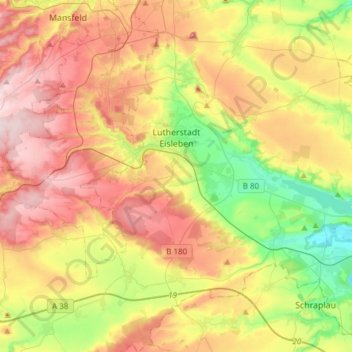
Name: Lutherstadt Eisleben topographic map, elevation, terrain.
Average elevation: 203 m
Minimum elevation: 73 m
Maximum elevation: 343 m
Other topographic maps
Click on a map to view its topography, its elevation and its terrain.
Kelbra (Kyffhäuser)
Germany > Saxony-Anhalt > Mansfeld-Südharz
Kelbra (Kyffhäuser), Goldene Aue, Mansfeld-Südharz, Saxony-Anhalt, 06537, Germany
Average elevation: 231 m