
Shefford topographic map
Interactive map
Click on the map to display elevation.
About this map
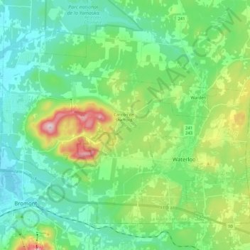
Name: Shefford topographic map, elevation, terrain.
Location: Shefford, La Haute-Yamaska, Estrie, Quebec, Canada (45.30719 -72.66647 45.42055 -72.46141)
Average elevation: 211 m
Minimum elevation: 108 m
Maximum elevation: 511 m
Other topographic maps
Click on a map to view its topography, its elevation and its terrain.
Mont Shefford
Canada > Quebec > La Haute-Yamaska > Shefford
Mont Shefford, Shefford, La Haute-Yamaska, Estrie, Quebec, J2M 1R5, Canada
Average elevation: 308 m