
Trois-Pistoles topographic map
Interactive map
Click on the map to display elevation.
About this map
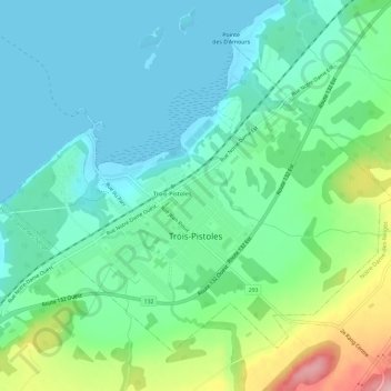
Name: Trois-Pistoles topographic map, elevation, terrain.
Average elevation: 43 m
Minimum elevation: -1 m
Maximum elevation: 169 m
Other topographic maps
Click on a map to view its topography, its elevation and its terrain.
Saint-Mathieu-de-Rioux
Canada > Quebec > Les Basques
Saint-Mathieu-de-Rioux, Les Basques, Bas-Saint-Laurent, Quebec, G0L 3T0, Canada
Average elevation: 230 m
Rivière-Trois-Pistoles
Canada > Quebec > Les Basques > Notre-Dame-des-Neiges > Rivière-Trois-Pistoles
Rivière-Trois-Pistoles, Notre-Dame-des-Neiges, Les Basques, Bas-Saint-Laurent, Quebec, G0L 4K0, Canada
Average elevation: 50 m
Saint-Guy
Canada > Quebec > Les Basques > Saint-Guy
Saint-Guy, Les Basques, Bas-Saint-Laurent, Quebec, Canada
Average elevation: 297 m