
Parowan topographic map
Interactive map
Click on the map to display elevation.
About this map
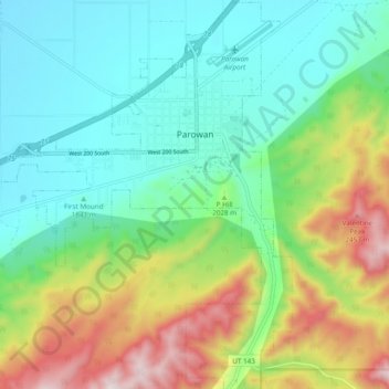
Name: Parowan topographic map, elevation, terrain.
Location: Parowan, Iron County, Utah, 84761, United States (37.79147 -112.88066 37.86791 -112.80414)
Average elevation: 2,002 m
Minimum elevation: 1,756 m
Maximum elevation: 2,536 m
Other topographic maps
Click on a map to view its topography, its elevation and its terrain.
Cedar City
United States > Utah > Iron County
Cedar City, Iron County, Utah, United States
Average elevation: 1,975 m
The Three Peaks
United States > Utah > Iron County
The Three Peaks, Iron County, Utah, United States
Average elevation: 1,789 m
Brian Head
United States > Utah > Iron County
Brian Head, Iron County, Utah, 84719, United States
Average elevation: 3,031 m
Cedar Breaks
United States > Utah > Iron County
Cedar Breaks, Iron County, Utah, United States
Average elevation: 2,843 m
Newcastle
United States > Utah > Iron County
Newcastle, Iron County, Utah, United States
Average elevation: 1,640 m
Cedar City
United States > Utah > Iron County > Cedar City > Cedar City
Cedar City, Iron County, Utah, 84720, United States
Average elevation: 2,087 m
Beryl
United States > Utah > Iron County
Beryl, Iron County, Utah, United States
Average elevation: 1,573 m
Enoch
United States > Utah > Iron County
Enoch, Iron County, Utah, United States
Average elevation: 1,769 m
Strawberry Point
United States > Utah > Iron County
Strawberry Point, Iron County, Utah, 84772, United States
Average elevation: 2,436 m
Kanarraville
United States > Utah > Iron County
Kanarraville, Iron County, Utah, 84742, United States
Average elevation: 1,721 m