
Wasagaming topographic map
Interactive map
Click on the map to display elevation.
About this map
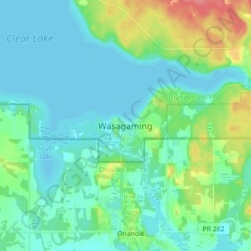
Name: Wasagaming topographic map, elevation, terrain.
Average elevation: 630 m
Minimum elevation: 615 m
Maximum elevation: 683 m
Other topographic maps
Click on a map to view its topography, its elevation and its terrain.
Riding Mountain National Park
Canada > Manitoba > Division No. 17 > Unorganized Division No. 17 > Wasagaming
Riding Mountain National Park, 135, Wasagaming Drive, Wasagaming Commercial Area, Wasagaming, Unorganized Division No. 17, Division No. 17, Manitoba, R0J 1N0, Canada
Average elevation: 488 m