
Guyuan topographic map
Interactive map
Click on the map to display elevation.
About this map
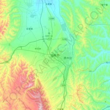
Name: Guyuan topographic map, elevation, terrain.
Location: Guyuan, Yuanzhou District, Guyuan City, Ningxia, China (35.85630 106.08086 36.17630 106.40086)
Average elevation: 1,872 m
Minimum elevation: 1,571 m
Maximum elevation: 2,700 m
Guyuan has a monsoon-influenced humid continental climate (Köppen Dwb), with long, cold, dry winters, and warm, rainier summers. With temperatures cooled by the elevation that exceeds 1,770 metres (5,810 ft), highs average slightly below freezing in January and reach only 25 °C (77 °F) in July. Much of the year's precipitation is delivered from June to September.