
Merseyside topographic map
Interactive map
Click on the map to display elevation.
About this map
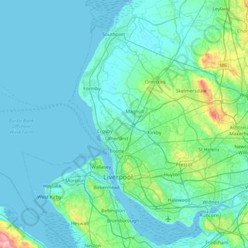
Name: Merseyside topographic map, elevation, terrain.
Average elevation: 23 m
Minimum elevation: -1 m
Maximum elevation: 243 m
Other topographic maps
Click on a map to view its topography, its elevation and its terrain.
Shotwick
United Kingdom > England > Cheshire West and Chester
Shotwick, Cheshire West and Chester, England, CH1 6HZ, United Kingdom
Average elevation: 20 m
Weaverham
United Kingdom > England > Cheshire West and Chester
Weaverham, Cheshire West and Chester, England, United Kingdom
Average elevation: 37 m
Carden
United Kingdom > England > Cheshire West and Chester
Carden, Cheshire West and Chester, England, United Kingdom
Average elevation: 51 m
Chester
United Kingdom > England > Cheshire West and Chester
Chester, Cheshire West and Chester, England, CH1 2ET, United Kingdom
Average elevation: 61 m