Lac de Serre-Ponçon topographic map
Interactive map
Click on the map to display elevation.
About this map
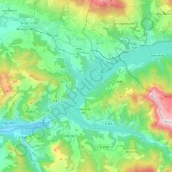
Name: Lac de Serre-Ponçon topographic map, elevation, terrain.
Average elevation: 1,089 m
Minimum elevation: 639 m
Maximum elevation: 2,358 m

Click on the map to display elevation.
Name: Lac de Serre-Ponçon topographic map, elevation, terrain.
Average elevation: 1,089 m
Minimum elevation: 639 m
Maximum elevation: 2,358 m