
Victoria Peak topographic map
Interactive map
Click on the map to display elevation.
About this map
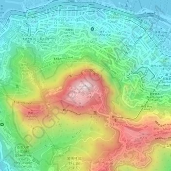
Name: Victoria Peak topographic map, elevation, terrain.
Location: Victoria Peak, Hong Kong Island, Hong Kong, N/A, China (22.27599 114.14541 22.27609 114.14551)
Average elevation: 209 m
Minimum elevation: -2 m
Maximum elevation: 534 m
Victoria Peak is a hill on the western half of Hong Kong Island. It is also known as Mount Austin, and locally as The Peak. With an elevation of 552 m (1,811 ft), it is the highest hill on Hong Kong island, ranked 31 in terms of elevation in Hong Kong (Tai Mo Shan is the highest point in Hong Kong with an elevation of 957 m (3,140 ft)).
Other topographic maps
Click on a map to view its topography, its elevation and its terrain.
Ap Lei Chau
China > Hong Kong > Hong Kong Island
Ap Lei Chau, Southern District, Hong Kong Island, Hong Kong, China
Average elevation: 25 m
Mount Davis
China > Hong Kong > Hong Kong Island
Mount Davis, Hong Kong Island, Hong Kong, China
Average elevation: 71 m
Wong Chuk Hang San Wai
China > Hong Kong > Hong Kong Island
Wong Chuk Hang San Wai, Southern District, Hong Kong Island, Hong Kong, China
Average elevation: 116 m
Violet Hill
China > Hong Kong > Hong Kong Island
Violet Hill, Hong Kong Island, Hong Kong, China
Average elevation: 180 m
Hong Kong Island
China > Hong Kong > Hong Kong Island
Hong Kong Island, Wan Chai District, Hong Kong, China
Average elevation: 122 m