
Helagsfjället topographic map
Interactive map
Click on the map to display elevation.
About this map
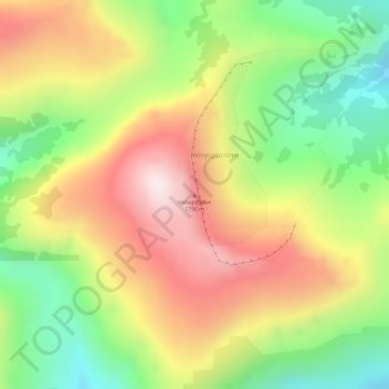
Name: Helagsfjället topographic map, elevation, terrain.
Location: Helagsfjället, Berg, Jämtland County, Region Norrland, Sweden (62.90451 12.45272 62.90461 12.45282)
Average elevation: 1,418 m
Minimum elevation: 1,121 m
Maximum elevation: 1,741 m
Other topographic maps
Click on a map to view its topography, its elevation and its terrain.
Linsell distrikt
Sweden > Jämtland County > Lofsdalen
Linsell distrikt, Lofsdalen, Härjedalens kommun, Jämtland County, Region Norrland, 840 85, Sweden
Average elevation: 672 m
Vemdalen
Sweden > Jämtland County > Vemdalen
Vemdalen, Härjedalens kommun, Jämtland County, Region Norrland, Sweden
Average elevation: 455 m
Öjarn
Sweden > Jämtland County > Öjarn
Öjarn, Strömsund, Jämtland County, Region Norrland, Sweden
Average elevation: 454 m
Tåsjöberget
Sweden > Jämtland County > Tåsjö District
Tåsjöberget, Tåsjö District, Strömsund, Province of Ångermanland, Jämtland County, Region Norrland, Sweden
Average elevation: 548 m
Åreskutan
Åreskutan, Åre, Jämtland County, Region Norrland, 83752, Sweden
Average elevation: 1,115 m
Härjedalens kommun
Härjedalens kommun, Jämtland County, Region Norrland, Sweden
Average elevation: 533 m