
Staten Island topographic map
Interactive map
Click on the map to display elevation.
About this map
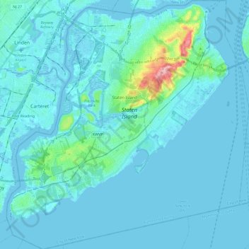
Name: Staten Island topographic map, elevation, terrain.
Location: Staten Island, New York, United States (40.49603 -74.25568 40.64889 -74.04925)
Average elevation: 11 m
Minimum elevation: -5 m
Maximum elevation: 122 m
Other topographic maps
Click on a map to view its topography, its elevation and its terrain.
New York County
United States > New York > New York
New York County, New York, United States
Average elevation: 16 m
Manhattan Island
United States > New York > New York
Manhattan Island, New York, United States
Average elevation: 17 m
Willets Point
United States > New York > New York
Willets Point, Queens, New York, 11359, United States
Average elevation: 2 m
Sawmill Creek
United States > New York > New York
Sawmill Creek, Chelsea, Richmond County, New York, 10311, United States
Average elevation: 3 m
Brooklyn
United States > New York > New York
Brooklyn, Kings County, New York, United States
Average elevation: 9 m
Queens County
United States > New York > New York
Queens County, New York, United States
Average elevation: 11 m
Little Italy
United States > New York > New York
Little Italy, Manhattan Community Board 2, Manhattan, New York County, New York, 10012-3332, United States
Average elevation: 14 m
The Bronx
United States > New York > New York
The Bronx, New York, United States
Average elevation: 23 m
Bronx County
United States > New York > New York
Bronx County, The Bronx, New York, United States
Average elevation: 21 m
Richmond County
United States > New York > New York
Richmond County, New York, United States
Average elevation: 9 m