
Abiko topographic map
Interactive map
Click on the map to display elevation.
About this map
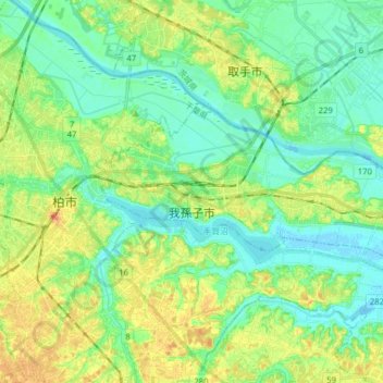
Name: Abiko topographic map, elevation, terrain.
Location: Abiko, Chiba Prefecture, Japan (35.84075 139.98867 35.90061 140.14646)
Average elevation: 15 m
Minimum elevation: -2 m
Maximum elevation: 41 m
Abiko is located in the northwestern part of Chiba prefecture, about 30 kilometers from the prefectural capital of Chiba, and within 30 to 40 kilometers of central Tokyo. It is separated from Ibaraki Prefecture in the north by the Tone River. The city is located on the Shimosa Plateau, with an average elevation of about 20 meters above sea level. The city stretches about 14 kilometers east-to-west and about 4 to 6 kilometers north-to-south.
Other topographic maps
Click on a map to view its topography, its elevation and its terrain.
Oyama
Oyama, Sunto County, Shizuoka Prefecture, Chubu Region, Japan
Average elevation: 737 m
Karuizawa
Karuizawa, Kitasaku County, Nagano Prefecture, Chubu Region, Japan
Average elevation: 1,117 m
Hinoemata
Hinoemata, Minamiaizu County, Fukushima Prefecture, Japan
Average elevation: 1,230 m
Kutchan
Kutchan, Abuta County, Shiribeshi Subprefecture, Hokkaido Prefecture, Japan
Average elevation: 374 m
Zama
Japan > Zama > Shindenjuku
Zama, Shindenjuku, Zama, Kanagawa Prefecture, 252-0027, Japan
Average elevation: 40 m
Odika
Odika, Kita-Matsuura County, Nagasaki Prefecture, Japan, Oshima Island
Average elevation: 3 m
Narusawa
Narusawa, Minamitsuru County, Yamanashi Prefecture, Chubu Region, Japan
Average elevation: 1,411 m
Shodoshima
Shodoshima, Shozu County, Kagawa Prefecture, 761-4411, Japan
Average elevation: 70 m
Sekigahara
Sekigahara, Fuwa County, Gifu Prefecture, 503-1592, Japan
Average elevation: 262 m