
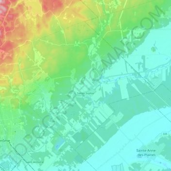
Sainte-Sophie topographic map
Interactive map
Click on the map to display elevation.
About this map
Name: Sainte-Sophie topographic map, elevation, terrain.
Average elevation: 109 m
Minimum elevation: 48 m
Maximum elevation: 335 m
Other topographic maps
Click on a map to view its topography, its elevation and its terrain.
Prévost
Canada > Quebec > La Rivière-du-Nord
Prévost, La Rivière-du-Nord, Laurentides, Quebec, J0R 1T0, Canada
Average elevation: 242 m
Saint-Colomban
Canada > Quebec > La Rivière-du-Nord
Saint-Colomban, La Rivière-du-Nord, Laurentides, Quebec, Canada
Average elevation: 150 m
Ruisseau de la Montée du Lac Écho
Canada > Quebec > La Rivière-du-Nord > Prévost
Ruisseau de la Montée du Lac Écho, Prévost, La Rivière-du-Nord, Laurentides, Quebec, J5L 2S2, Canada
Average elevation: 198 m
Saint-Hippolyte
Canada > Quebec > La Rivière-du-Nord
Saint-Hippolyte, La Rivière-du-Nord, Laurentides, Quebec, Canada
Average elevation: 272 m
Saint-Jérôme
Canada > Quebec > La Rivière-du-Nord
Saint-Jérôme, La Rivière-du-Nord, Laurentides, Quebec, Canada
Average elevation: 139 m