
Lake Como topographic map
Interactive map
Click on the map to display elevation.
About this map
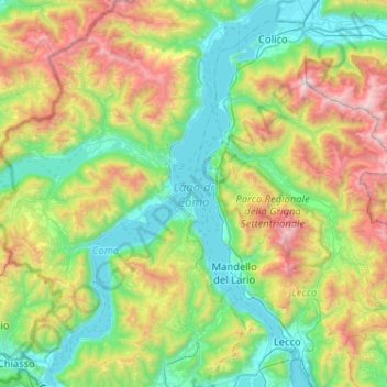
Name: Lake Como topographic map, elevation, terrain.
Location: Lake Como, Como, Lombardy, 23829, Italy (45.81316 9.06673 46.17036 9.38897)
Average elevation: 885 m
Minimum elevation: 188 m
Maximum elevation: 2,593 m
Lake Como weather is humid subtropical (Cfa in the Köppen climate classification). In the winter, the lake helps to maintain a higher temperature in the surrounding region. Average daily temperatures range from about 3.7 °C (39 °F) in January to 23.4 °C (74 °F) in July, according to historical weather data from Como. Water temperatures can reach an average of 24 °C (75 °F) during the month of July. Snowfall is erratic and primarily affects the higher elevations. Rainfall is heaviest in May and lowest during the winter months.
Other topographic maps
Click on a map to view its topography, its elevation and its terrain.
Aureggio
Italy > Lombardy > Como > San Giovanni
Aureggio, San Giovanni, Bellagio, Como, Lombardy, 22021, Italy
Average elevation: 249 m