
Piney Creek topographic map
Interactive map
Click on the map to display elevation.
About this map
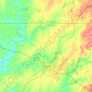
Name: Piney Creek topographic map, elevation, terrain.
Location: Piney Creek, Carroll County, Maryland, 21787, United States (39.65057 -77.26570 39.72484 -77.09704)
Average elevation: 152 m
Minimum elevation: 104 m
Maximum elevation: 221 m
Other topographic maps
Click on a map to view its topography, its elevation and its terrain.
Bear Branch
United States > Maryland > Carroll County > Brown Heights
Bear Branch, Brown Heights, Carroll County, Maryland, United States
Average elevation: 145 m
Mount Airy
United States > Maryland > Carroll County
Mount Airy, Carroll County, Maryland, 21771, United States
Average elevation: 221 m
Belle Grove Square
United States > Maryland > Carroll County > Westminster
Belle Grove Square, Westminster, Carroll County, Maryland, 21157, United States
Average elevation: 224 m
Finksburg
United States > Maryland > Carroll County
Finksburg, Carroll County, Maryland, 21048, United States
Average elevation: 158 m
Hampstead
United States > Maryland > Carroll County
Hampstead, Carroll County, Maryland, United States
Average elevation: 242 m
New Windsor
United States > Maryland > Carroll County
New Windsor, Carroll County, Maryland, United States
Average elevation: 154 m
Eldersburg
United States > Maryland > Carroll County
Eldersburg, Carroll County, Maryland, 21784, United States
Average elevation: 166 m
Keymar
United States > Maryland > Carroll County
Keymar, Carroll County, Maryland, 21757, United States
Average elevation: 128 m
Gaither
United States > Maryland > Carroll County
Gaither, Carroll County, Maryland, 21784, United States
Average elevation: 161 m
Union Bridge
United States > Maryland > Carroll County
Union Bridge, Carroll County, Maryland, United States
Average elevation: 138 m
Avondale Wildlife Management Area
United States > Maryland > Carroll County > Chapel Heights
Avondale Wildlife Management Area, Chapel Heights, Carroll County, Maryland, United States
Average elevation: 206 m
Melrose
United States > Maryland > Carroll County
Melrose, Carroll County, Maryland, United States
Average elevation: 262 m
Heritage
United States > Maryland > Carroll County
Heritage, Carroll County, Maryland, United States
Average elevation: 214 m
Washington Heights
United States > Maryland > Carroll County > Westminster
Washington Heights, Westminster, Carroll County, Maryland, 21157, United States
Average elevation: 233 m
Taneytown
United States > Maryland > Carroll County
Taneytown, Carroll County, Maryland, 21787, United States
Average elevation: 153 m
Millers
United States > Maryland > Carroll County
Millers, Carroll County, Maryland, 21102, United States
Average elevation: 266 m
Union Mills Homestead Park
United States > Maryland > Carroll County > Union Mills
Union Mills Homestead Park, Union Mills, Carroll County, Maryland, United States
Average elevation: 195 m
Furnace Hills
United States > Maryland > Carroll County > Westminster
Furnace Hills, Westminster, Carroll County, Maryland, 21157, United States
Average elevation: 211 m
Marston
United States > Maryland > Carroll County
Marston, Carroll County, Maryland, 21776, United States
Average elevation: 189 m
Liberty Reservoir
United States > Maryland > Carroll County
Liberty Reservoir, Carroll County, Maryland, United States
Average elevation: 170 m
Cape Horn South
United States > Maryland > Carroll County
Cape Horn South, Carroll County, Maryland, United States
Average elevation: 256 m
Meadow Brook
United States > Maryland > Carroll County > Taneytown
Meadow Brook, Taneytown, Carroll County, Maryland, 21787, United States
Average elevation: 156 m
Woodbine
United States > Maryland > Carroll County
Woodbine, Carroll County, Maryland, 21797, United States
Average elevation: 182 m
Mill Stream Hills
United States > Maryland > Carroll County
Mill Stream Hills, Carroll County, Maryland, 21088, United States
Average elevation: 238 m
Silver Run
United States > Maryland > Carroll County
Silver Run, Carroll County, Maryland, United States
Average elevation: 198 m
Eldersburg
United States > Maryland > Carroll County > Eldersburg
Eldersburg, Carroll County, Maryland, 21784, United States
Average elevation: 167 m
Forest Hills
United States > Maryland > Carroll County > Forest Hills
Forest Hills, Carroll County, Maryland, 21157, United States
Average elevation: 227 m
Manchester
United States > Maryland > Carroll County
Manchester, Carroll County, Maryland, United States
Average elevation: 276 m
Westminster
United States > Maryland > Carroll County
Westminster, Carroll County, Maryland, United States
Average elevation: 226 m
Mount Airy
United States > Maryland > Carroll County > Mount Airy > Mount Airy
Mount Airy, Carroll County, Maryland, 21771, United States
Average elevation: 217 m
Sykesville
United States > Maryland > Carroll County
Sykesville, Carroll County, Maryland, United States
Average elevation: 152 m