
Kriváň topographic map
Interactive map
Click on the map to display elevation.
About this map
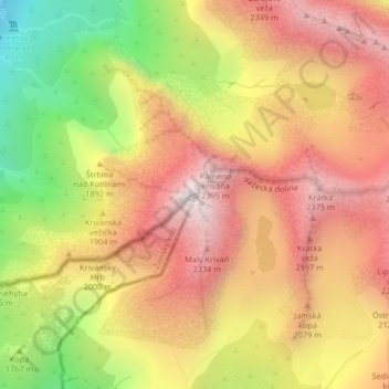
Name: Kriváň topographic map, elevation, terrain.
Average elevation: 1,913 m
Minimum elevation: 1,204 m
Maximum elevation: 2,445 m
The relative elevations of the two mountains were determined by the English natural historian Robert Townson, who ascended both peaks in August 1793 and also made an early recorded comment on Kriváň's aesthetic appeal:
Other topographic maps
Click on a map to view its topography, its elevation and its terrain.
Gerlachovský štít
Slovakia > Region of Prešov > District of Poprad > Vysoké Tatry
Gerlachovský štít, Vysoké Tatry, District of Poprad, Region of Prešov, Eastern Slovakia, 059 84, Slovakia
Average elevation: 2,103 m