
Grand Canyon topographic map
Interactive map
Click on the map to display elevation.
About this map
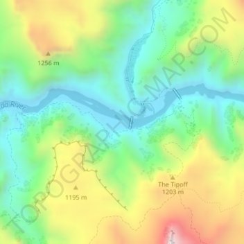
Name: Grand Canyon topographic map, elevation, terrain.
Location: Grand Canyon, Coconino County, Arizona, United States (36.09769 -112.09681 36.09779 -112.09671)
Average elevation: 1,021 m
Minimum elevation: 738 m
Maximum elevation: 1,519 m
Uplift associated with mountain formation later moved these sediments thousands of feet upward and created the Colorado Plateau. The higher elevation has also resulted in greater precipitation in the Colorado River drainage area, but not enough to change the Grand Canyon area from being semi-arid. The uplift of the Colorado Plateau is uneven, and the Kaibab Plateau that the Grand Canyon bisects is over one thousand feet (300 m) higher at the North Rim than at the South Rim. Almost all runoff from the North Rim (which also gets more rain and snow) flows toward the Grand Canyon, while much of the runoff on the plateau behind the South Rim flows away from the canyon (following the general tilt). The result is deeper and longer tributary washes and canyons on the north side and shorter and steeper side canyons on the south side.
Other topographic maps
Click on a map to view its topography, its elevation and its terrain.
Darling
United States > Arizona > Coconino County
Darling, Coconino County, Arizona, United States
Average elevation: 1,916 m
Roden Crater
United States > Arizona > Coconino County
Roden Crater, Coconino County, Arizona, United States
Average elevation: 1,497 m
Page
United States > Arizona > Coconino County
Page, Coconino County, Arizona, United States
Average elevation: 1,225 m
Munds Park
United States > Arizona > Coconino County
Munds Park, Coconino County, Arizona, 86017, United States
Average elevation: 2,049 m
Kachina Village
United States > Arizona > Coconino County > Kachina Village
Kachina Village, Coconino County, Arizona, United States
Average elevation: 2,076 m
Grand Canyon Village
United States > Arizona > Coconino County
Grand Canyon Village, Coconino County, Arizona, United States
Average elevation: 1,778 m
Glen Canyon
United States > Arizona > Coconino County
Glen Canyon, Coconino County, Arizona, 86040-0418, United States
Average elevation: 1,248 m
Happy Jack
United States > Arizona > Coconino County > Happy Jack
Happy Jack, Coconino County, Arizona, United States
Average elevation: 2,284 m
Flagstaff
United States > Arizona > Coconino County
Flagstaff, Coconino County, Arizona, United States
Average elevation: 2,176 m
North Rim
United States > Arizona > Coconino County
North Rim, Coconino County, Arizona, United States
Average elevation: 2,297 m