
Fhain topographic map
Interactive map
Click on the map to display elevation.
About this map
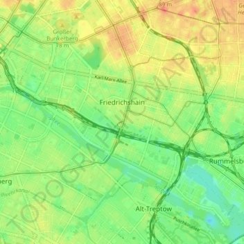
Name: Fhain topographic map, elevation, terrain.
Location: Fhain, Friedrichshain-Kreuzberg, Berlin, Germany (52.48605 13.41975 52.53103 13.49144)
Average elevation: 43 m
Minimum elevation: 22 m
Maximum elevation: 65 m
Other topographic maps
Click on a map to view its topography, its elevation and its terrain.
Battle of Berlin
Battle of Berlin, Gertrud-Kolmar-Straße, Dorotheenstadt, Mitte, Berlin, 10117, Germany
Average elevation: 39 m
Friedrichshain-Kreuzberg
Friedrichshain-Kreuzberg, Berlin, Germany
Average elevation: 45 m
Charlottenburg-Wilmersdorf
Charlottenburg-Wilmersdorf, Berlin, Germany
Average elevation: 44 m