
County Dublin topographic map
Interactive map
Click on the map to display elevation.
About this map
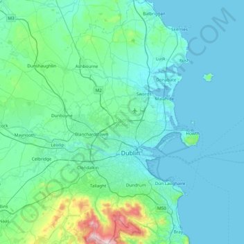
Name: County Dublin topographic map, elevation, terrain.
Location: County Dublin, Leinster, Ireland (53.17826 -6.54689 53.63471 -5.99450)
Average elevation: 71 m
Minimum elevation: -1 m
Maximum elevation: 738 m
Dublin is a topographically varied region. The city centre is generally very low-lying, and many areas of coastal Dublin are at or near sea-level. In the south of the county, the topography rises steeply from sea-level at the coast to over 500 metres (1,600 ft) in just a few kilometres. This natural barrier has resulted in densely populated coastal settlements in Dún Laoghaire–Rathdown and westward urban sprawl in South Dublin. In contrast, Fingal is generally rural in nature and much less densely populated than the rest of the county. Consequently, Fingal is significantly larger than the other three local authorities and covers about 49.5% of County Dublin's land area. Fingal is also perhaps the flattest region in Ireland, with the low-lying Naul Hills rising to a maximum height of just 176 metres (577 ft).
Other topographic maps
Click on a map to view its topography, its elevation and its terrain.
Cleggan
Cleggan, Conamara Municipal District, County Galway, Connacht, H71 HY36, Ireland
Average elevation: 29 m
Saint Catherines
Saint Catherines, Boherglass ED, Killaloe Municipal District, County Clare, Munster, Ireland
Average elevation: 91 m
Roundwood
Roundwood, The Municipal District of Wicklow, County Wicklow, Leinster, Ireland
Average elevation: 242 m
Newfarm
Newfarm, The Rower, The Municipal District of Callan — Thomastown, County Kilkenny, Leinster, Ireland
Average elevation: 33 m
Millstreet
Millstreet, Municipal District of Macroom, County Cork, Munster, Ireland
Average elevation: 140 m
Road
Road, Ballyburly ED, The Municipal District of Edenderry, County Offaly, Leinster, Ireland
Average elevation: 87 m
Wexford
Wexford, The Borough District of Wexford, County Wexford, Leinster, Ireland
Average elevation: 23 m
The Municipal District of Piltown
The Municipal District of Piltown, County Kilkenny, Leinster, Ireland
Average elevation: 89 m
Dún Laoghaire-Rathdown
Dún Laoghaire-Rathdown, County Dublin, Leinster, Ireland
Average elevation: 139 m
Rathmichael (Bray) ED
Rathmichael (Bray) ED, The Municipal District of Bray, County Wicklow, Leinster, Ireland
Average elevation: 36 m
Listowel
Listowel, Listowel Municipal District, County Kerry, Munster, V31 YK58, Ireland
Average elevation: 43 m
The Municipal District of Callan — Thomastown
The Municipal District of Callan — Thomastown, County Kilkenny, Leinster, Ireland
Average elevation: 100 m
Elphin
Elphin, Elphin ED, Boyle Municipal District, County Roscommon, Connacht, Ireland
Average elevation: 76 m
Market
Ireland > County Limerick > Limerick
Market, The Metropolitan District of Limerick City, Limerick, County Limerick, Munster, Ireland
Average elevation: 12 m
Whitechurch
Whitechurch, Municipal District of Cobh, County Cork, Munster, Ireland
Average elevation: 110 m
Waterfall
Waterfall, Inishkenny, Municipal District of Carrigaline, County Cork, Munster, T12 CYF2, Ireland
Average elevation: 96 m
Bailieborough
Bailieborough, Bailieborough ED, Bailieborough-Cootehill Municipal District, County Cavan, Ulster, A82 NX86, Ireland
Average elevation: 162 m
Cloyne
Cloyne, Cloyne ED, The Municipal District of East Cork, County Cork, Munster, P25 P792, Ireland
Average elevation: 40 m
Killeagh
Killeagh, The Municipal District of East Cork, County Cork, Munster, P36 KN61, Ireland
Average elevation: 64 m
Aughrim
Aughrim, The Municipal District of Arklow, County Wicklow, Leinster, Y14 HT72, Ireland
Average elevation: 123 m
Gortnahoe
Gortnahoe, The Municipal District of Thurles, County Tipperary, Munster, Ireland
Average elevation: 135 m
The Municipal District of Newcastle West
The Municipal District of Newcastle West, County Limerick, Munster, Ireland
Average elevation: 117 m
North West Slob
North West Slob, Ardcavan ED, The Borough District of Wexford, County Wexford, Leinster, Ireland
Average elevation: 1 m
Castledown
Castledown, Heathstown ED, The Municipal District of Mullingar — Kinnegad, County Westmeath, Leinster, Ireland
Average elevation: 97 m
Cliffs of Moher
Cliffs of Moher, Ballysteen ED, West Clare Municipal District, County Clare, Munster, Ireland
Average elevation: 55 m
Hollyfort
Hollyfort, The Municipal District of Gorey — Kilmuckridge, County Wexford, Leinster, Ireland
Average elevation: 145 m
Lough Loung
Lough Loung, Ballynakill ED, Ballinasloe Municipal District, County Galway, Connacht, Ireland
Average elevation: 65 m
Athlone
Athlone, County Westmeath, Leinster, Ireland
Average elevation: 43 m
Monbay Lower
Monbay Lower, Rossminoge ED, The Municipal District of Gorey — Kilmuckridge, County Wexford, Leinster, Ireland
Average elevation: 136 m
Ballymahon Municipal District
Ballymahon Municipal District, County Longford, Leinster, Ireland
Average elevation: 63 m
Mountain River
Mountain River, The Municipal District of Muinebeag, County Carlow, Leinster, Ireland
Average elevation: 136 m
The Municipal District of Gorey — Kilmuckridge
The Municipal District of Gorey — Kilmuckridge, County Wexford, Leinster, Ireland
Average elevation: 58 m
Kilquane
Ireland > County Cork > Municipal District of Cobh
Kilquane, Knockraha, Municipal District of Cobh, County Cork, Munster, Ireland
Average elevation: 131 m
Red Island
Ireland > County Cavan > Carrickclevan
Red Island, Carrickclevan, Drumcarban ED, Ballyjamesduff Municipal District, County Cavan, Ulster, Ireland
Average elevation: 76 m
Great Blasket Island
Great Blasket Island, Toghroinn ceantair Dún Chaoin, Kenmare Municipal District, County Kerry, Munster, Ireland
Average elevation: 21 m
Aughrim
Aughrim, Ballinasloe Municipal District, County Galway, Connacht, Ireland
Average elevation: 68 m
Mount Eagle
Mount Eagle, Westport-Belmullet Municipal District, County Mayo, Connacht, Ireland
Average elevation: 274 m