
Caloocan topographic map
Interactive map
Click on the map to display elevation.
About this map
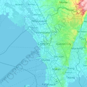
Name: Caloocan topographic map, elevation, terrain.
Location: Caloocan, Metro Manila, 1475, Philippines (14.49713 120.82411 14.81713 121.14411)
Average elevation: 23 m
Minimum elevation: -3 m
Maximum elevation: 279 m
Other topographic maps
Click on a map to view its topography, its elevation and its terrain.
Camarin
Camarin, District 1, Caloocan, Northern Manila District, Metro Manila, Philippines
Average elevation: 68 m
Barangay 34
Barangay 34, Zone 3, Maypajo, District 2, Caloocan, Northern Manila District, Metro Manila, Philippines
Average elevation: 9 m