
Saint John topographic map
Interactive map
Click on the map to display elevation.
About this map
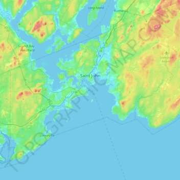
Name: Saint John topographic map, elevation, terrain.
Location: Saint John, Saint John County, New Brunswick, Canada (45.13325 -66.24562 45.37693 -65.83886)
Average elevation: 38 m
Minimum elevation: -7 m
Maximum elevation: 226 m
The topography surrounding Saint John is hilly; a result of the influence of two coastal mountain ranges which run along the Bay of Fundy – the St. Croix Highlands and the Caledonia Highlands. The soil throughout the region is extremely rocky with frequent granite outcrops. The coastal plain hosts numerous freshwater lakes in the eastern, western and northern parts of the city.
Other topographic maps
Click on a map to view its topography, its elevation and its terrain.
Drury Cove
Canada > New Brunswick > Saint John County > Saint John
Drury Cove, Saint John, Saint John County, New Brunswick, E2K 5K7, Canada
Average elevation: 24 m
Tynemouth Creek
Canada > New Brunswick > Saint John County
Tynemouth Creek, Saint Martins Parish, Saint John County, New Brunswick, Canada
Average elevation: 32 m
Little River
Canada > New Brunswick > Saint John County > Saint John
Little River, Saint John, Saint John County, New Brunswick, E2J 1N8, Canada
Average elevation: 9 m
Lorneville
Canada > New Brunswick > Saint John County > Saint John > Lorneville
Lorneville, Saint John, Saint John County, New Brunswick, E2M 7G6, Canada
Average elevation: 18 m