
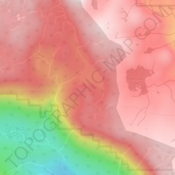
Forbidden Plateau topographic map
Interactive map
Click on the map to display elevation.
About this map
Name: Forbidden Plateau topographic map, elevation, terrain.
Average elevation: 1,041 m
Minimum elevation: 602 m
Maximum elevation: 1,234 m
Other topographic maps
Click on a map to view its topography, its elevation and its terrain.
Nymph Falls
Canada > British Columbia > Comox Valley Regional District > Area C (Puntledge/Black Creek)
Nymph Falls, Area C (Puntledge/Black Creek), Comox Valley Regional District, British Columbia, V9J 1R5, Canada
Average elevation: 128 m
Croteau Lake
Canada > British Columbia > Comox Valley Regional District > Area C (Puntledge/Black Creek)
Croteau Lake, Area C (Puntledge/Black Creek), Comox Valley Regional District, British Columbia, Canada
Average elevation: 1,195 m
Miracle Beach
Canada > British Columbia > Comox Valley Regional District > Area C (Puntledge/Black Creek) > Miracle Beach
Miracle Beach, Area C (Puntledge/Black Creek), Comox Valley Regional District, British Columbia, V9J 1A0, Canada
Average elevation: 30 m
MacAulay Heights
Canada > British Columbia > Comox Valley Regional District > Area C (Puntledge/Black Creek) > MacAulay Heights
MacAulay Heights, Area C (Puntledge/Black Creek), Comox Valley Regional District, British Columbia, Canada
Average elevation: 94 m
Mount Becher
Canada > British Columbia > Comox Valley Regional District > Area C (Puntledge/Black Creek)
Mount Becher, Area C (Puntledge/Black Creek), Comox Valley Regional District, British Columbia, Canada
Average elevation: 1,035 m
Puntledge
Canada > British Columbia > Comox Valley Regional District > Area C (Puntledge/Black Creek)
Puntledge, Area C (Puntledge/Black Creek), Comox Valley Regional District, British Columbia, V9N 9L9, Canada
Average elevation: 115 m