
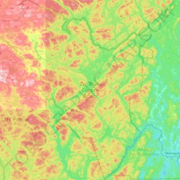
ZEC Bras-Coupé–Désert topographic map
Interactive map
Click on the map to display elevation.
About this map
Name: ZEC Bras-Coupé–Désert topographic map, elevation, terrain.
Average elevation: 294 m
Minimum elevation: 161 m
Maximum elevation: 538 m
Other topographic maps
Click on a map to view its topography, its elevation and its terrain.
Lac Jean Pere
Canada > Quebec > Lac-Pythonga
Lac Jean Pere, Route 117, Lac-Pythonga, La Vallée-de-la-Gatineau, Outaouais, Quebec, Canada
Average elevation: 386 m
Lac Gippaw
Canada > Quebec > Lac-Pythonga
Lac Gippaw, Lac-Pythonga, La Vallée-de-la-Gatineau, Outaouais, Quebec, Canada
Average elevation: 306 m
Lac Érié
Canada > Quebec > Lac-Pythonga
Lac Érié, Lac-Pythonga, La Vallée-de-la-Gatineau, Outaouais, Quebec, Canada
Average elevation: 430 m
Réservoir Cabonga
Canada > Quebec > Lac-Pythonga
Réservoir Cabonga, La Verendrye 25, Lac-Pythonga, La Vallée-de-la-Gatineau, Outaouais, Quebec, Canada
Average elevation: 384 m
Rivière Gens de Terre
Canada > Quebec > Lac-Pythonga
Rivière Gens de Terre, Lac-Pythonga, La Vallée-de-la-Gatineau, Outaouais, Quebec, Canada
Average elevation: 371 m