
Independence Charter Township topographic map
Interactive map
Click on the map to display elevation.
About this map
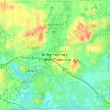
Name: Independence Charter Township topographic map, elevation, terrain.
Average elevation: 318 m
Minimum elevation: 288 m
Maximum elevation: 385 m
Independence Township is located along the Hillsdale-Lapeer Moraine Range. The highest hill along that range in Independence Township is Pine Knob, at 1,221 feet. It is also the highest point in Southeastern Michigan. Only three miles away is Waterford Hill, the second highest hill in Independence Township with an elevation of 1,150 feet. Atop Waterford Hill is Olympus Circle, the highest elevation of any residential street in Independence Township.
Other topographic maps
Click on a map to view its topography, its elevation and its terrain.
Lake Orion
United States > Michigan > Oakland County
Lake Orion, Oakland County, Michigan, 48362, United States
Average elevation: 303 m
White Lake Charter Township
United States > Michigan > Oakland County
White Lake Charter Township, Oakland County, Michigan, United States
Average elevation: 303 m
Bloomfield Hills
United States > Michigan > Oakland County
Bloomfield Hills, Oakland County, Michigan, 48304, United States
Average elevation: 261 m
Highland Charter Township
United States > Michigan > Oakland County
Highland Charter Township, Oakland County, Michigan, 48357, United States
Average elevation: 315 m
Rochester
United States > Michigan > Oakland County
Rochester, Oakland County, Michigan, United States
Average elevation: 242 m
Troy
United States > Michigan > Oakland County
Troy, Oakland County, Michigan, United States
Average elevation: 221 m
Walled Lake
United States > Michigan > Oakland County
Walled Lake, Oakland County, Michigan, United States
Average elevation: 287 m
Greens Lake
United States > Michigan > Oakland County
Greens Lake, Oakland County, Michigan, United States
Average elevation: 309 m
Oakley Park
United States > Michigan > Oakland County > Commerce Charter Township
Oakley Park, Commerce Charter Township, Oakland County, Michigan, 48390, United States
Average elevation: 282 m
Rossman Lake
United States > Michigan > Oakland County
Rossman Lake, Oakland County, Michigan, United States
Average elevation: 314 m
Southfield
United States > Michigan > Oakland County
Southfield, Oakland County, Michigan, United States
Average elevation: 210 m
Huntington Woods
United States > Michigan > Oakland County
Huntington Woods, Oakland County, Michigan, 48070, United States
Average elevation: 204 m
Keego Harbor
United States > Michigan > Oakland County
Keego Harbor, Oakland County, Michigan, United States
Average elevation: 286 m
Auburn Hills
United States > Michigan > Oakland County
Auburn Hills, Oakland County, Michigan, 48326, United States
Average elevation: 284 m
Wixom
United States > Michigan > Oakland County > Wixom
Wixom, Oakland County, Michigan, United States
Average elevation: 288 m
Novi
United States > Michigan > Oakland County
Novi, Oakland County, Michigan, United States
Average elevation: 280 m
Pleasant Ridge
United States > Michigan > Oakland County > Pleasant Ridge
Pleasant Ridge, Oakland County, Michigan, United States
Average elevation: 201 m
Royal Oak
United States > Michigan > Oakland County
Royal Oak, Oakland County, Michigan, United States
Average elevation: 203 m
South Lyon
United States > Michigan > Oakland County > South Lyon
South Lyon, Oakland County, Michigan, United States
Average elevation: 282 m
Orion Charter Township
United States > Michigan > Oakland County
Orion Charter Township, Oakland County, Michigan, United States
Average elevation: 306 m
Lakeville
United States > Michigan > Oakland County > Lakeville
Lakeville, Oakland County, Michigan, 48366, United States
Average elevation: 299 m
Pontiac
United States > Michigan > Oakland County
Pontiac, Oakland County, Michigan, United States
Average elevation: 290 m