
Val-Racine topographic map
Interactive map
Click on the map to display elevation.
About this map
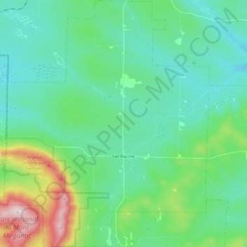
Name: Val-Racine topographic map, elevation, terrain.
Location: Val-Racine, Le Granit, Estrie, Quebec, Canada (45.43759 -71.16252 45.56513 -71.01061)
Average elevation: 558 m
Minimum elevation: 411 m
Maximum elevation: 1,102 m
Other topographic maps
Click on a map to view its topography, its elevation and its terrain.
Montagne de Marbre
Canada > Quebec > Le Granit > Notre-Dame-des-Bois
Montagne de Marbre, Notre-Dame-des-Bois, Le Granit, Estrie, Quebec, Canada
Average elevation: 713 m
Saint-Augustin-de-Woburn
Saint-Augustin-de-Woburn, Le Granit, Estrie, Quebec, G0Y 1R0, Canada
Average elevation: 620 m
Lac-Mégantic
Lac-Mégantic, Le Granit, Estrie, Quebec, Canada
Average elevation: 434 m
Saint-Robert-Bellarmin
Canada > Quebec > Le Granit > Saint-Robert-Bellarmin
Saint-Robert-Bellarmin, Le Granit, Estrie, Quebec, Canada
Average elevation: 466 m
Saint-Ludger
Saint-Ludger, Le Granit, Estrie, Quebec, G0M 1W0, Canada
Average elevation: 451 m
Mont Gosford
Canada > Quebec > Le Granit > Saint-Augustin-de-Woburn
Mont Gosford, Saint-Augustin-de-Woburn, Le Granit, Estrie, Quebec, Canada
Average elevation: 933 m