
Greenwood topographic map
Interactive map
Click on the map to display elevation.
About this map
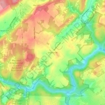
Name: Greenwood topographic map, elevation, terrain.
Average elevation: 93 m
Minimum elevation: 35 m
Maximum elevation: 148 m
Other topographic maps
Click on a map to view its topography, its elevation and its terrain.
Hydes
United States > Maryland > Baltimore County > Towson
Hydes, Towson, Baltimore County, Maryland, 21013, United States
Average elevation: 123 m
Brooklandville
United States > Maryland > Baltimore County > Towson
Brooklandville, Towson, Baltimore County, Maryland, 21022, United States
Average elevation: 122 m
Rockland
United States > Maryland > Baltimore County > Towson
Rockland, Towson, Baltimore County, Maryland, 21022, United States
Average elevation: 107 m
Towson
United States > Maryland > Baltimore County > Towson
Towson, Baltimore County, Maryland, United States
Average elevation: 114 m
Long Green
United States > Maryland > Baltimore County > Towson
Long Green, Towson, Baltimore County, Maryland, 21057, United States
Average elevation: 129 m
Glen Arm
United States > Maryland > Baltimore County > Towson
Glen Arm, Towson, Baltimore County, Maryland, 21057, United States
Average elevation: 109 m