
İzmit topographic map
Interactive map
Click on the map to display elevation.
About this map
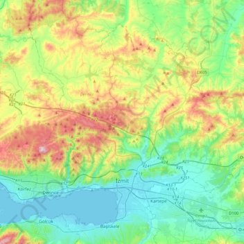
Name: İzmit topographic map, elevation, terrain.
Location: İzmit, Kocaeli, Marmara Region, Turkey (40.72030 29.85393 40.97193 30.26747)
Average elevation: 194 m
Minimum elevation: -1 m
Maximum elevation: 641 m
The city is mostly built on hill slopes because of the cramped area, while flat plains surround the gulf, near the sea. This topographic structure divided the city into two parts. The first was created on flat plains, where the city center is. The railway and highway networks pass from this area which is close to the Sea of Marmara. The second part was built on hills, with many historic houses from the Ottoman period in the old quarters.
Other topographic maps
Click on a map to view its topography, its elevation and its terrain.