
Shantou topographic map
Interactive map
Click on the map to display elevation.
About this map
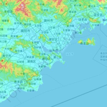
Name: Shantou topographic map, elevation, terrain.
Location: Shantou, Guangdong, China (23.03488 116.23961 23.64342 117.38674)
Average elevation: 58 m
Minimum elevation: -2 m
Maximum elevation: 1,230 m
Other topographic maps
Click on a map to view its topography, its elevation and its terrain.
Xiaoguwei
China > Guangdong > Guangzhou City
Xiaoguwei, Xiaoguwei Subdistrict, Panyu District, Guangzhou City, Guangdong, 510006, China
Average elevation: 7 m
Jinshazhou
China > Guangdong > Guangzhou City
Jinshazhou, Baiyun, Baiyun District, Guangzhou City, Guangdong, China
Average elevation: 7 m
Guangzhou City
China > Guangdong > Guangzhou City
东涌镇, Nansha District, Guangzhou City, Guangdong, China
Average elevation: 3 m