
Oita Prefecture topographic map
Interactive map
Click on the map to display elevation.
About this map
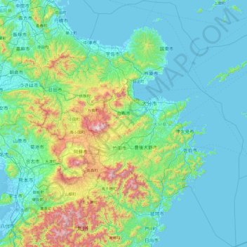
Name: Oita Prefecture topographic map, elevation, terrain.
Location: Oita Prefecture, Japan (32.37889 130.82475 33.84561 132.27609)
Average elevation: 242 m
Minimum elevation: -5 m
Maximum elevation: 1,753 m
The origins of the name Ōita are documented in a report from the early 8th century called the Chronicles of Bungo (豊後国風土記, bungonokuni-fudoki) . According to the document, when Emperor Keikō visited the Kyushu region, stopping first in Toyo-no-Kuni, he exclaimed that 'This is a vast land, indeed. It shall be known as Okita-Kuni!' Okita-Kuni, meaning "Land of the Great Fields", later came to be written as "Ōita". Present day interpretations based on Ōita's topography state that Oita's name comes from "Okita", meaning "many fields", rather than "vast" or "great" field, because of Ōita's complex terrain.
Other topographic maps
Click on a map to view its topography, its elevation and its terrain.
Oyama
Oyama, Sunto County, Shizuoka Prefecture, Chubu Region, Japan
Average elevation: 737 m
Karuizawa
Karuizawa, Kitasaku County, Nagano Prefecture, Chubu Region, Japan
Average elevation: 1,117 m
Hinoemata
Hinoemata, Minamiaizu County, Fukushima Prefecture, Japan
Average elevation: 1,230 m
Kutchan
Kutchan, Abuta County, Shiribeshi Subprefecture, Hokkaido Prefecture, Japan
Average elevation: 374 m
Zama
Japan > Zama > Shindenjuku
Zama, Shindenjuku, Zama, Kanagawa Prefecture, 252-0027, Japan
Average elevation: 40 m
Odika
Odika, Kita-Matsuura County, Nagasaki Prefecture, Japan, Oshima Island
Average elevation: 3 m
Narusawa
Narusawa, Minamitsuru County, Yamanashi Prefecture, Chubu Region, Japan
Average elevation: 1,411 m
Sekigahara
Sekigahara, Fuwa County, Gifu Prefecture, 503-1592, Japan
Average elevation: 262 m
Shodoshima
Shodoshima, Shozu County, Kagawa Prefecture, 761-4411, Japan
Average elevation: 70 m