
Vijayapura topographic map
Interactive map
Click on the map to display elevation.
About this map
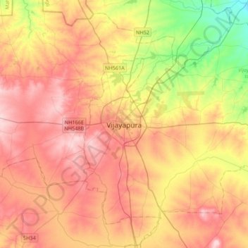
Name: Vijayapura topographic map, elevation, terrain.
Average elevation: 590 m
Minimum elevation: 490 m
Maximum elevation: 670 m
Bijapur has a semi-arid climate. It is located at 16°50′N 75°42′E / 16.83°N 75.7°E / 16.83; 75.7. It has an average elevation of 606 metres (1988 ft). The district has two types of soil. First one is, "deep black soil" (or yeari bhoomi), which is good for the crops like jawar, wheat, pulses, sunflower, etc. The major portion of the district consists of this kind of soil which has a great moisture-holding capacity. Second one is "red soil‟ (or masari /maddi bhoomi), which is generally poor, good for irrigation and horticulture. Krishna river, which is the most important river of the district. It flows about 125 miles in the district. A dam is built across the river at Almatti, Bhima river flows in northern part of district for about 20 miles. It overflows in the rainy season and spreads over a wider area, which is thereby rendered extremely fertile land. In central part of district Doni river flows.