
Skellefteå topographic map
Interactive map
Click on the map to display elevation.
About this map
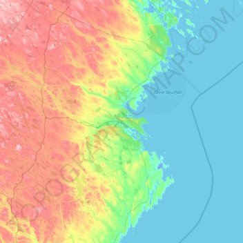
Name: Skellefteå topographic map, elevation, terrain.
Average elevation: 121 m
Minimum elevation: -6 m
Maximum elevation: 525 m
Other topographic maps
Click on a map to view its topography, its elevation and its terrain.
Åmliden
Sweden > Västerbotten County > Åmliden
Åmliden, Norsjö, Province Västerbotten, Västerbotten County, Region Norrland, Sweden
Average elevation: 388 m
Vitberget
Vitberget, Umeå, Province Västerbotten, Västerbotten County, Region Norrland, Sweden
Average elevation: 193 m
Hemavan
Sweden > Västerbotten County > Hemavan
Hemavan, Storumans kommun, Västerbotten County, Region Norrland, 920 66, Sweden
Average elevation: 540 m