
Machu Picchu topographic map
Interactive map
Click on the map to display elevation.
About this map
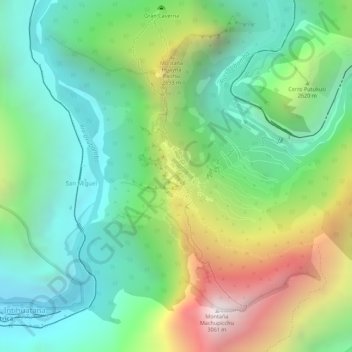
Name: Machu Picchu topographic map, elevation, terrain.
Average elevation: 2,227 m
Minimum elevation: 1,773 m
Maximum elevation: 3,031 m
Other topographic maps
Click on a map to view its topography, its elevation and its terrain.
Rio Aquascalientes
Peru > Cusco > Machupicchu > Machupicchu Pueblo
Rio Aquascalientes, Machupicchu Pueblo, Machupicchu, Province of Urubamba, Cusco, 08681, Peru
Average elevation: 2,642 m
San Miguel
Peru > Cusco > Machupicchu > Intihuatana
San Miguel, Intihuatana, Machupicchu, Province of Urubamba, Cusco, 08680, Peru
Average elevation: 2,262 m
Machupicchu
Peru > Cusco > Machupicchu
Machupicchu, Province of Urubamba, Cusco, Peru
Average elevation: 3,640 m
Postcard Picture
Peru > Cusco > Machupicchu > San Miguel
Postcard Picture, Path to Inka Bridge, San Miguel, Machupicchu, Province of Urubamba, Cusco, 08680, Peru
Average elevation: 2,236 m