
Waukegan topographic map
Interactive map
Click on the map to display elevation.
About this map
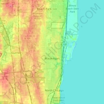
Name: Waukegan topographic map, elevation, terrain.
Location: Waukegan, Lake County, Illinois, United States (42.30938 -87.96442 42.43266 -87.80421)
Average elevation: 197 m
Minimum elevation: 172 m
Maximum elevation: 236 m
Waukegan is located at 42°22′13″N 87°52′16″W / 42.37028°N 87.87111°W / 42.37028; -87.87111 (42.3703140, -87.8711404). Waukegan is on the shore of Lake Michigan, about 11 miles (18 km) south of the border with Wisconsin and 35 miles (56 km) north of downtown Chicago, at an elevation of about 715 feet (218 m) above sea level.