
Scotland topographic map
Interactive map
Click on the map to display elevation.
About this map
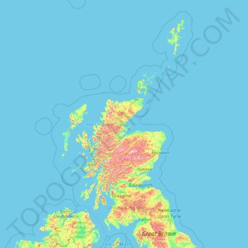
Name: Scotland topographic map, elevation, terrain.
Location: Scotland, United Kingdom (54.43398 -14.01552 61.06100 -0.32092)
Average elevation: 36 m
Minimum elevation: 0 m
Maximum elevation: 1,259 m
A significant exception to the above are the fossil-bearing beds of Old Red Sandstones found principally along the Moray Firth coast. The Highlands are generally mountainous and the highest elevations in the British Isles are found here. Scotland has over 790 islands divided into four main groups: Shetland, Orkney, and the Inner Hebrides and Outer Hebrides. There are numerous bodies of freshwater including Loch Lomond and Loch Ness. Some parts of the coastline consist of machair, a low-lying dune pasture land.
Other topographic maps
Click on a map to view its topography, its elevation and its terrain.
Bucks Green
United Kingdom > England > West Sussex > Horsham
Bucks Green, Horsham, West Sussex, England, RH12 3JN, United Kingdom
Average elevation: 47 m
Weybridge
United Kingdom > England > Surrey > Elmbridge
Weybridge, Elmbridge, Surrey, England, KT13 8RT, United Kingdom
Average elevation: 21 m
Random
United Kingdom > England > Random
Random, Shropshire, West Midlands, England, DY14 0QD, United Kingdom
Average elevation: 347 m
Syleham
United Kingdom > England > Suffolk > Mid Suffolk
Syleham, Mid Suffolk, Suffolk, England, United Kingdom
Average elevation: 40 m
Hodge Hill
United Kingdom > England > Birmingham
Hodge Hill, Birmingham, West Midlands Combined Authority, England, B36 8EG, United Kingdom
Average elevation: 101 m
Caersws
United Kingdom > Wales > Powys
Caersws, Powys, Wales, SY17 5DS, United Kingdom
Average elevation: 145 m
Arthur's Seat
United Kingdom > Scotland > City of Edinburgh
Arthur's Seat, City of Edinburgh, Scotland, EH8 8HG, United Kingdom
Average elevation: 69 m
Ruthin
United Kingdom > Wales > Denbighshire
Ruthin, Denbighshire, Wales, LL15 1BU, United Kingdom
Average elevation: 162 m
Bawsey
United Kingdom > England > Norfolk > King's Lynn and West Norfolk
Bawsey, King's Lynn and West Norfolk, Norfolk, England, United Kingdom
Average elevation: 16 m
Rotherham
Rotherham, South Yorkshire, England, United Kingdom
Average elevation: 101 m
Dyke
United Kingdom > Scotland > Moray
Dyke, Moray, Scotland, IV36 2TJ, United Kingdom
Average elevation: 24 m
Stockton-on-the-Forest
United Kingdom > England > York
Stockton-on-the-Forest, York, England, United Kingdom
Average elevation: 22 m
Airdrie
United Kingdom > Scotland > North Lanarkshire
Airdrie, North Lanarkshire, Scotland, ML6 6BU, United Kingdom
Average elevation: 136 m
Hawick
United Kingdom > Scotland > Scottish Borders
Hawick, Scottish Borders, Scotland, TD9 9EG, United Kingdom
Average elevation: 199 m
Waddington
United Kingdom > England > Lancashire > Ribble Valley
Waddington, Ribble Valley, Lancashire, England, United Kingdom
Average elevation: 164 m
St Helens
St Helens, Liverpool City Region, England, United Kingdom
Average elevation: 49 m
Langholm
United Kingdom > Scotland > Dumfries and Galloway
Langholm, Dumfries and Galloway, Scotland, DG13 0JQ, United Kingdom
Average elevation: 185 m
Brynmawr
United Kingdom > Wales > Blaenau Gwent
Brynmawr, Blaenau Gwent, Wales, NP23 4AN, United Kingdom
Average elevation: 399 m
Pomeroy
United Kingdom > Northern Ireland > County Tyrone
Pomeroy, County Tyrone, Northern Ireland, BT70 2RD, United Kingdom
Average elevation: 169 m
Blackburn
United Kingdom > England > Blackburn with Darwen
Blackburn, Blackburn with Darwen, England, BB1 7DP, United Kingdom
Average elevation: 157 m
Walton-on-Thames
United Kingdom > England > Surrey
Walton-on-Thames, Surrey, England, United Kingdom
Average elevation: 17 m
Nuneaton and Bedworth
United Kingdom > England > Warwickshire
Nuneaton and Bedworth, Warwickshire, England, United Kingdom
Average elevation: 108 m
Warmley
United Kingdom > England > South Gloucestershire
Warmley, Siston, South Gloucestershire, West of England, England, BS15 4PP, United Kingdom
Average elevation: 69 m
North Berwick
United Kingdom > Scotland > East Lothian
North Berwick, East Lothian, Scotland, EH39 4HE, United Kingdom
Average elevation: 21 m
London
United Kingdom > England > London
London, Westminster, England, SW1A 2DX, United Kingdom
Average elevation: 42 m
Bury St Edmunds
United Kingdom > England > Suffolk > West Suffolk
Bury St Edmunds, West Suffolk, Suffolk, England, United Kingdom
Average elevation: 54 m
Llanvetherine
United Kingdom > Wales > Monmouthshire
Llanvetherine, Monmouthshire, Wales, NP7 8RD, United Kingdom
Average elevation: 125 m
Neath
United Kingdom > Wales > West Glamorgan
Neath, West Glamorgan, Wales, SA11 1DT, United Kingdom
Average elevation: 115 m
Shepton Mallet
United Kingdom > England > Somerset
Shepton Mallet, Somerset, England, United Kingdom
Average elevation: 173 m
Wadhurst
United Kingdom > England > East Sussex > Wealden
Wadhurst, Wealden, East Sussex, England, United Kingdom
Average elevation: 109 m
Cwm Parc
United Kingdom > Wales > Rhondda Cynon Taf
Cwm Parc, Rhondda Cynon Taf, Wales, CF42 6LY, United Kingdom
Average elevation: 309 m
St Andrews
United Kingdom > Scotland > Fife
St Andrews, Fife, Scotland, KY16 9PA, United Kingdom
Average elevation: 38 m
Brabourne Lees
United Kingdom > England > Kent > Ashford
Brabourne Lees, Ashford, Kent, England, TN25 6QG, United Kingdom
Average elevation: 73 m
Trowbridge
United Kingdom > England > Wiltshire
Trowbridge, Wiltshire, England, United Kingdom
Average elevation: 47 m
Pierowall
United Kingdom > Scotland > Orkney Islands
Pierowall, Orkney Islands, Scotland, KW17 2DJ, United Kingdom
Average elevation: 20 m
Ruthven
United Kingdom > Scotland > Aberdeenshire
Ruthven, Aberdeenshire, Scotland, AB54 4SG, United Kingdom
Average elevation: 132 m
Packmoor
United Kingdom > England > Stoke-on-Trent
Packmoor, Stoke-on-Trent, England, ST7 4SW, United Kingdom
Average elevation: 194 m
Upper Tean
United Kingdom > England > Staffordshire > Staffordshire Moorlands
Upper Tean, Staffordshire Moorlands, Staffordshire, England, ST10 4EH, United Kingdom
Average elevation: 175 m
Tremeirchion
United Kingdom > Wales > Denbighshire
Tremeirchion, Denbighshire, Wales, United Kingdom
Average elevation: 123 m
Esher
United Kingdom > England > Surrey > Elmbridge
Esher, Elmbridge, Surrey, England, United Kingdom
Average elevation: 21 m
Berwick St. John
United Kingdom > England > Wiltshire
Berwick St. John, Wiltshire, England, United Kingdom
Average elevation: 168 m
Silbury Hill
United Kingdom > England > Wiltshire > Beckhampton
Silbury Hill, Silbury Cottages, Beckhampton, Avebury, Wiltshire, England, United Kingdom
Average elevation: 166 m
Baldock
United Kingdom > England > Hertfordshire > North Hertfordshire
Baldock, North Hertfordshire, Hertfordshire, England, SG7 6AS, United Kingdom
Average elevation: 90 m
Winterborne Monkton
United Kingdom > England > Dorset
Winterborne Monkton, Dorset, England, United Kingdom
Average elevation: 92 m
Woodlands Road
United Kingdom > England > Staffordshire > Stafford
Woodlands Road, Stafford, Staffordshire, England, United Kingdom
Average elevation: 85 m
Steep
United Kingdom > England > Hampshire > East Hampshire > Steep
Steep, East Hampshire, Hampshire, England, United Kingdom
Average elevation: 115 m
Orway
United Kingdom > England > Devon > Mid Devon > Saint Hill
Orway, Kentisbeare, Saint Hill, Mid Devon, Devon, England, EX15 2EX, United Kingdom
Average elevation: 155 m
Garsdale
United Kingdom > England > Westmorland and Furness > Sedbergh
Garsdale, Sedbergh, Westmorland and Furness, England, United Kingdom
Average elevation: 361 m