
Merley topographic map
Interactive map
Click on the map to display elevation.
About this map
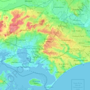
Name: Merley topographic map, elevation, terrain.
Average elevation: 23 m
Minimum elevation: -7 m
Maximum elevation: 89 m
Other topographic maps
Click on a map to view its topography, its elevation and its terrain.
Bournemouth
United Kingdom > England > Bournemouth, Christchurch and Poole > Kinson
Bournemouth, Kinson, Bournemouth, Christchurch and Poole, England, United Kingdom
Average elevation: 17 m
Bournemouth
United Kingdom > England > Bournemouth, Christchurch and Poole > Bournemouth
Bournemouth, Bournemouth, Christchurch and Poole, England, BH2 6EG, United Kingdom
Average elevation: 21 m