
Lac La Biche County topographic map
Interactive map
Click on the map to display elevation.
About this map
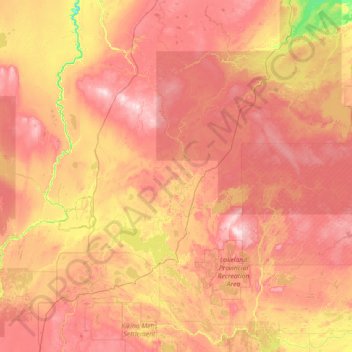
Name: Lac La Biche County topographic map, elevation, terrain.
Location: Lac La Biche County, Alberta, Canada (54.35486 -112.80042 55.98198 -110.31442)
Average elevation: 624 m
Minimum elevation: 427 m
Maximum elevation: 864 m
Other topographic maps
Click on a map to view its topography, its elevation and its terrain.
Edmonton
Canada > Alberta > Division No. 11
Edmonton, Division No. 11, Alberta, Canada
Average elevation: 690 m
Jasper National Park
Jasper National Park, Alberta, T0E 1E0, Canada
Average elevation: 1,782 m
Cochrane
Canada > Alberta > Town of Cochrane > Cochrane
Cochrane, Town of Cochrane, Alberta, T4V 2A7, Canada
Average elevation: 1,205 m
Canmore
Canada > Alberta > Division No. 15
Canmore, Division No. 15, Alberta, T1W 2H4, Canada
Average elevation: 1,565 m
Lake Louise
Canada > Alberta > Division No. 15
Lake Louise, Division No. 15, Alberta, Canada
Average elevation: 1,617 m
Lethbridge
Canada > Alberta > Lethbridge
Lethbridge, City of Lethbridge, Alberta, T1J 4L3, Canada
Average elevation: 918 m
Grande Prairie
Canada > Alberta > Grande Prairie
Grande Prairie, City of Grande Prairie, Alberta, T8V 2X3, Canada
Average elevation: 668 m
Fort McMurray
Canada > Alberta > Division No. 16
Fort McMurray, Division No. 16, Alberta, Canada
Average elevation: 345 m
Drumheller
Canada > Alberta > Division No. 5
Drumheller, Division No. 5, Alberta, T0J 0Y2, Canada
Average elevation: 763 m
Bragg Creek
Bragg Creek, Census Divsion No. 6, Alberta, T0L 0K0, Canada
Average elevation: 1,384 m
Nose Hill Park
Nose Hill Park, Calgary, Alberta, T3K 2P6, Canada
Average elevation: 1,174 m
Kananaskis
Canada > Alberta > Municipal District of Bighorn > Kananaskis
Kananaskis, Municipal District of Bighorn, Alberta, T0L 2C0, Canada
Average elevation: 1,426 m
Brown-Lowery Provincial Park
Canada > Alberta > Foothills County
Brown-Lowery Provincial Park, Foothills County, Alberta, Canada
Average elevation: 1,353 m
Half Moon Lake
Canada > Alberta > Division No. 11
Half Moon Lake, Division No. 11, Alberta, Canada
Average elevation: 752 m
Meeting Creek
Canada > Alberta > Division No. 10
Meeting Creek, Division No. 10, Alberta, Canada
Average elevation: 763 m
Diamond City
Canada > Alberta > Division No. 2
Diamond City, Division No. 2, Alberta, Canada
Average elevation: 891 m
Central McDougall Park
Canada > Alberta > Division No. 11 > Edmonton
Central McDougall Park, Central McDougall, Central Core, Edmonton, Division No. 11, Alberta, Canada
Average elevation: 666 m
Driftpile
Canada > Alberta > Division No. 17
Driftpile, Division No. 17, Alberta, Canada
Average elevation: 590 m
Big Lake
Canada > Alberta > Division No. 11 > St. Albert
Big Lake, St. Albert, Division No. 11, Alberta, Canada
Average elevation: 669 m
Village of Barnwell
Canada > Alberta > Division No. 2
Village of Barnwell, Division No. 2, Alberta, Canada
Average elevation: 832 m
Mildred Lake
Canada > Alberta > Division No. 15 > Municipality of Jasper
Mildred Lake, Municipality of Jasper, Division No. 15, Alberta, Canada
Average elevation: 1,046 m
Chain Lakes Provincial Park
Canada > Alberta > Division No. 15
Chain Lakes Provincial Park, Division No. 15, Alberta, Canada
Average elevation: 1,365 m
Crowsnest Pass
Canada > Alberta > Crowsnest Pass
Crowsnest Pass, Municipality of Crowsnest Pass, Alberta, T0K 0M0, Canada
Average elevation: 1,410 m
Eagle Hill
Canada > Alberta > Division No. 15
Eagle Hill, Division No. 15, Alberta, Canada
Average elevation: 1,576 m
Waterton Lakes National Park
Canada > Alberta > Division No. 3
Waterton Lakes National Park, Division No. 3, Alberta, Canada
Average elevation: 1,778 m
Little Bow Provincial Park
Canada > Alberta > Division No. 5
Little Bow Provincial Park, Division No. 5, Alberta, Canada
Average elevation: 902 m
St. Mary Reservoir Provincial Recreation Area
Canada > Alberta > Division No. 3
St. Mary Reservoir Provincial Recreation Area, Township Road 50A, Division No. 3, Alberta, Canada
Average elevation: 1,101 m
Little Elbow Provincial Recreation Area
Canada > Alberta > Division No. 15
Little Elbow Provincial Recreation Area, Big Elbow Trail, Division No. 15, Alberta, Canada
Average elevation: 1,672 m
Tillebrook Provincial Park
Canada > Alberta > Division No. 2
Tillebrook Provincial Park, Division No. 2, Alberta, Canada
Average elevation: 763 m
Kinbrook Island Provincial Park
Canada > Alberta > Division No. 2
Kinbrook Island Provincial Park, Division No. 2, Alberta, Canada
Average elevation: 763 m
Etherington Creek Provincial Recreation Area
Canada > Alberta > Division No. 15
Etherington Creek Provincial Recreation Area, Etherington-Baril Ridge Route, Division No. 15, Alberta, Canada
Average elevation: 1,749 m
Wyndham-Carseland Provincial Park
Canada > Alberta > Wheatland County
Wyndham-Carseland Provincial Park, Wheatland County, Alberta, Canada
Average elevation: 943 m
Paul Kane Park
Canada > Alberta > Division No. 11 > Edmonton
Paul Kane Park, Oliver, Central Core, Edmonton, Division No. 11, Alberta, Canada
Average elevation: 655 m
Second Lake
Canada > Alberta > Division No. 15 > Municipality of Jasper
Second Lake, Municipality of Jasper, Division No. 15, Alberta, Canada
Average elevation: 1,155 m