
Ten Mile Lake Provincial Park topographic map
Interactive map
Click on the map to display elevation.
About this map
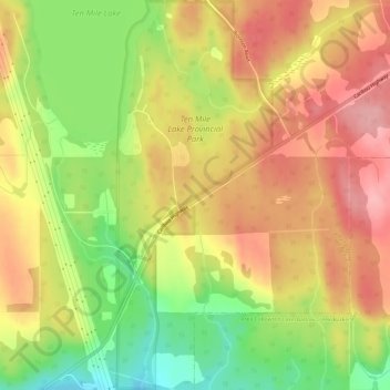
Name: Ten Mile Lake Provincial Park topographic map, elevation, terrain.
Average elevation: 726 m
Minimum elevation: 653 m
Maximum elevation: 783 m
Other topographic maps
Click on a map to view its topography, its elevation and its terrain.
Bouchie Lake
Canada > British Columbia > Cariboo Regional District > Area B (Quesnel West/Bouchie Lake)
Bouchie Lake, Area B (Quesnel West/Bouchie Lake), Cariboo Regional District, British Columbia, Canada
Average elevation: 699 m