
Maycroft topographic map
Interactive map
Click on the map to display elevation.
About this map
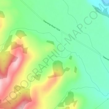
Name: Maycroft topographic map, elevation, terrain.
Average elevation: 1,373 m
Minimum elevation: 1,284 m
Maximum elevation: 1,515 m
Other topographic maps
Click on a map to view its topography, its elevation and its terrain.
Pincher Creek
Canada > Alberta > Municipal District of Pincher Creek No. 9
Pincher Creek, Municipal District of Pincher Creek No. 9, Alberta, Canada
Average elevation: 1,313 m
Beaver Mines Lake
Canada > Alberta > Municipal District of Pincher Creek No. 9
Beaver Mines Lake, Municipal District of Pincher Creek No. 9, Alberta, Canada
Average elevation: 1,538 m