
Saugeen Shores topographic map
Interactive map
Click on the map to display elevation.
About this map
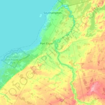
Name: Saugeen Shores topographic map, elevation, terrain.
Location: Saugeen Shores, Bruce County, Ontario, Canada (44.31534 -81.52071 44.52029 -81.28348)
Average elevation: 215 m
Minimum elevation: 173 m
Maximum elevation: 296 m
Other topographic maps
Click on a map to view its topography, its elevation and its terrain.
Crane Lake
Canada > Ontario > Bruce County
Crane Lake, Municipality of Northern Bruce Peninsula, Bruce County, Ontario, Canada
Average elevation: 204 m
Huron-Kinloss
Canada > Ontario > Bruce County
Huron-Kinloss, Bruce County, Ontario, N0G 2R0, Canada
Average elevation: 256 m
Kincardine
Canada > Ontario > Bruce County
Kincardine, Bruce County, Ontario, Canada
Average elevation: 206 m
Chesley
Canada > Ontario > Bruce County > Arran–Elderslie
Chesley, Arran–Elderslie, Bruce County, Southwestern Ontario, Ontario, N0G 1L0, Canada
Average elevation: 271 m
Greenock
Canada > Ontario > Bruce County > Brockton
Greenock, Brockton, Bruce County, Southwestern Ontario, Ontario, N0G 1K0, Canada
Average elevation: 272 m
Municipality of Northern Bruce Peninsula
Canada > Ontario > Bruce County
Municipality of Northern Bruce Peninsula, Bruce County, Ontario, Canada
Average elevation: 183 m
Port Elgin
Canada > Ontario > Bruce County
Port Elgin, Saugeen Shores, Bruce County, Ontario, N0H 2C0, Canada
Average elevation: 199 m
Spry Lake
Canada > Ontario > Bruce County
Spry Lake, South Bruce Peninsula, Bruce County, Southwestern Ontario, Ontario, Canada
Average elevation: 192 m
Southampton
Canada > Ontario > Bruce County
Southampton, Saugeen Shores, Bruce County, Ontario, N0H 2L0, Canada
Average elevation: 190 m
South Bruce Peninsula
Canada > Ontario > Bruce County
South Bruce Peninsula, Bruce County, Southwestern Ontario, Ontario, Canada
Average elevation: 199 m
Sauble Beach
Canada > Ontario > Bruce County
Sauble Beach, South Bruce Peninsula, Bruce County, Southwestern Ontario, Ontario, N0H 2G0, Canada
Average elevation: 188 m
Wiarton
Canada > Ontario > Bruce County
Wiarton, South Bruce Peninsula, Bruce County, Southwestern Ontario, Ontario, N0H 2T0, Canada
Average elevation: 205 m
Bruce Peninsula
Canada > Ontario > Bruce County
Bruce Peninsula, Municipality of Northern Bruce Peninsula, Bruce County, Southwestern Ontario, Ontario, N0H 2R0, Canada
Average elevation: 186 m
Miller Lake
Canada > Ontario > Bruce County
Miller Lake, Municipality of Northern Bruce Peninsula, Bruce County, Ontario, N0H 1Z0, Canada
Average elevation: 200 m
Lions' Head Lookout
Canada > Ontario > Bruce County
Lions' Head Lookout, Bruce Trail, Municipality of Northern Bruce Peninsula, Bruce County, Southwestern Ontario, Ontario, N0H 1W0, Canada
Average elevation: 198 m
Tobermory
Canada > Ontario > Bruce County
Tobermory, Bruce County, Ontario, N0H 2R0, Canada
Average elevation: 191 m
Ripley
Canada > Ontario > Bruce County > Huron-Kinloss
Ripley, Huron-Kinloss, Bruce County, Southwestern Ontario, Ontario, N0G 2R0, Canada
Average elevation: 244 m
Swan Lake Drain
Canada > Ontario > Bruce County
Swan Lake Drain, Municipality of Northern Bruce Peninsula, Bruce County, Southwestern Ontario, Ontario, N0H 1W0, Canada
Average elevation: 187 m
Lion's Head Provincial Nature Reserve
Canada > Ontario > Bruce County
Lion's Head Provincial Nature Reserve, McKay's Harbour Side Trail (Bruce Trail), Municipality of Northern Bruce Peninsula, Bruce County, Ontario, Canada
Average elevation: 206 m
Sauble Falls
Canada > Ontario > Bruce County
Sauble Falls, South Bruce Peninsula, Bruce County, Southwestern Ontario, Ontario, N0H 2G0, Canada
Average elevation: 190 m
Sauble River
Canada > Ontario > Bruce County > Sauble Beach
Sauble River, Sauble Beach, South Bruce Peninsula, Bruce County, Southwestern Ontario, Ontario, N0H 2G0, Canada
Average elevation: 191 m
Arran–Elderslie
Canada > Ontario > Bruce County > Arran–Elderslie
Arran–Elderslie, Bruce County, Southwestern Ontario, Ontario, Canada
Average elevation: 244 m
Kincardine
Canada > Ontario > Bruce County > Kincardine > Kincardine
Kincardine, Bruce County, Southwestern Ontario, Ontario, N2Z 2Y2, Canada
Average elevation: 198 m
Walkerton
Canada > Ontario > Bruce County > Brockton
Walkerton, Brockton, Bruce County, Ontario, N0G 2V0, Canada
Average elevation: 286 m
Niagara Escarpment
Canada > Ontario > Bruce County
Niagara Escarpment, Municipality of Northern Bruce Peninsula, Bruce County, Southwestern Ontario, Ontario, Canada
Average elevation: 195 m
Fathom Five National Marine Park
Canada > Ontario > Bruce County
Fathom Five National Marine Park, Municipality of Northern Bruce Peninsula, Bruce County, Ontario, N0H 2R0, Canada
Average elevation: 179 m
Lucknow
Canada > Ontario > Bruce County > Huron-Kinloss
Lucknow, Huron-Kinloss, Bruce County, Ontario, N0G 2H0, Canada
Average elevation: 284 m
Patterson Lake
Canada > Ontario > Bruce County
Patterson Lake, South Bruce Peninsula, Bruce County, Southwestern Ontario, Ontario, Canada
Average elevation: 191 m
Hepworth
Canada > Ontario > Bruce County
Hepworth, South Bruce Peninsula, Bruce County, Southwestern Ontario, Ontario, N0H 1P0, Canada
Average elevation: 223 m
Mildmay
Canada > Ontario > Bruce County > South Bruce
Mildmay, South Bruce, Bruce County, Southwestern Ontario, Ontario, N0G 2J0, Canada
Average elevation: 322 m