
Make a donation
Gear up for your next adventure:
As an Amazon Associate, this site earns from qualifying purchases at no extra cost to you.
Mesolongi topographic map
Click on the map to display elevation.
Make a donation
Gear up for your next adventure:
As an Amazon Associate, this site earns from qualifying purchases at no extra cost to you.
About this map
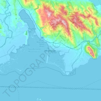
Name: Mesolongi topographic map, elevation, terrain.
Average elevation: 108 m
Minimum elevation: -4 m
Maximum elevation: 954 m
Make a donation
Gear up for your next adventure:
As an Amazon Associate, this site earns from qualifying purchases at no extra cost to you.
Other topographic maps
Click on a map to view its topography, its elevation and its terrain.
Ambracian Gulf
Greece > Peloponnese, Western Greece and the Ionian > Aetolia-Acarnania Regional Unit
Average elevation: 112 m
Municipal Unit of Amphilohia
Greece > Peloponnese, Western Greece and the Ionian > Aetolia-Acarnania Regional Unit
Average elevation: 321 m
Municipal Unit of Palairos
Greece > Peloponnese, Western Greece and the Ionian > Aetolia-Acarnania Regional Unit
Average elevation: 335 m
Municipal Unit of Anaktorio
Greece > Peloponnese, Western Greece and the Ionian > Aetolia-Acarnania Regional Unit
Average elevation: 184 m
Make a donation
Gear up for your next adventure:
As an Amazon Associate, this site earns from qualifying purchases at no extra cost to you.
Municipal Unit of Menidi
Greece > Peloponnese, Western Greece and the Ionian > Aetolia-Acarnania Regional Unit
Average elevation: 380 m
Municipal Unit of Palairos
Greece > Peloponnese, Western Greece and the Ionian > Aetolia-Acarnania Regional Unit
Average elevation: 335 m