
Hidden Valley topographic map
Interactive map
Click on the map to display elevation.
About this map
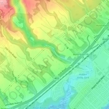
Name: Hidden Valley topographic map, elevation, terrain.
Average elevation: 127 m
Minimum elevation: 76 m
Maximum elevation: 203 m
Other topographic maps
Click on a map to view its topography, its elevation and its terrain.
Niagara Escarpment
Canada > Ontario > Burlington
Niagara Escarpment, Wetland Trail, Tyandaga, Nelson, Burlington, Halton Region, Ontario, L0R 2H7, Canada
Average elevation: 216 m
Mount Nemo
Canada > Ontario > Burlington > Mount Nemo
Mount Nemo, Burlington, Halton Region, Golden Horseshoe, Ontario, L7P 0N2, Canada
Average elevation: 248 m
Hamilton Harbour
Canada > Ontario > Burlington
Hamilton Harbour, Bayswater Avenue, La Salle, Burlington, Halton Region, Ontario, L7T 0A4, Canada
Average elevation: 74 m
Hager Creek
Canada > Ontario > Burlington
Hager Creek, Burlington, Halton Region, Golden Horseshoe, Ontario, L7P 3G9, Canada
Average elevation: 126 m
Falcon Creek
Canada > Ontario > Burlington
Falcon Creek, Burlington, Halton Region, Ontario, L7T 0A4, Canada
Average elevation: 90 m