
Make a donation
Gear up for your next adventure:
As an Amazon Associate, this site earns from qualifying purchases at no extra cost to you.
Municipality of Rhineland topographic map
Click on the map to display elevation.
Make a donation
Gear up for your next adventure:
As an Amazon Associate, this site earns from qualifying purchases at no extra cost to you.
About this map
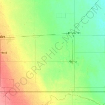
Name: Municipality of Rhineland topographic map, elevation, terrain.
Location: Municipality of Rhineland, Manitoba, Canada (49.00047 -97.86635 49.26657 -97.32494)
Average elevation: 254 m
Minimum elevation: 236 m
Maximum elevation: 292 m
Manitoba trails, hiking, mountain biking, running and outdoor activities
Make a donation
Gear up for your next adventure:
As an Amazon Associate, this site earns from qualifying purchases at no extra cost to you.
Other topographic maps
Click on a map to view its topography, its elevation and its terrain.
Make a donation
Gear up for your next adventure:
As an Amazon Associate, this site earns from qualifying purchases at no extra cost to you.
Make a donation
Gear up for your next adventure:
As an Amazon Associate, this site earns from qualifying purchases at no extra cost to you.
Red River Floodway
Canada > Manitoba > Rural Municipality of Springfield > Winnipeg
Average elevation: 236 m
Make a donation
Gear up for your next adventure:
As an Amazon Associate, this site earns from qualifying purchases at no extra cost to you.
Make a donation
Gear up for your next adventure:
As an Amazon Associate, this site earns from qualifying purchases at no extra cost to you.
Make a donation
Gear up for your next adventure:
As an Amazon Associate, this site earns from qualifying purchases at no extra cost to you.
Bird River
Canada > Manitoba > Division No. 1 > Rural Municipality of Alexander
Average elevation: 287 m
Make a donation
Gear up for your next adventure:
As an Amazon Associate, this site earns from qualifying purchases at no extra cost to you.
Make a donation
Gear up for your next adventure:
As an Amazon Associate, this site earns from qualifying purchases at no extra cost to you.
Make a donation
Gear up for your next adventure:
As an Amazon Associate, this site earns from qualifying purchases at no extra cost to you.
Make a donation
Gear up for your next adventure:
As an Amazon Associate, this site earns from qualifying purchases at no extra cost to you.
Winnipeg
Canada > Manitoba > Winnipeg > Winnipeg
Winnipeg lies at the bottom of the Red River Valley, a flood plain with an extremely flat topography. It is on the eastern edge of the Canadian Prairies in Western Canada and is known as the "Gateway to the West". Winnipeg is bordered by tallgrass prairie to the west and south and the aspen parkland to the…
Average elevation: 236 m
Make a donation
Gear up for your next adventure:
As an Amazon Associate, this site earns from qualifying purchases at no extra cost to you.
Moose Lake
Canada > Manitoba > Division No. 20 > Unorganized Division No. 20 (South)
Average elevation: 724 m
Make a donation
Gear up for your next adventure:
As an Amazon Associate, this site earns from qualifying purchases at no extra cost to you.
Make a donation
Gear up for your next adventure:
As an Amazon Associate, this site earns from qualifying purchases at no extra cost to you.
O-Pipon-Na-Piwin Cree Nation
Canada > Manitoba > O-Pipon-Na-Piwin Cree Nation
Average elevation: 269 m
Little Saskatchewan First Nation
Canada > Manitoba > Little Saskatchewan First Nation
Average elevation: 247 m
Make a donation
Gear up for your next adventure:
As an Amazon Associate, this site earns from qualifying purchases at no extra cost to you.
Rock Lake
Canada > Manitoba > Division No. 20 > Unorganized Division No. 20 (South)
Average elevation: 658 m
Beaufort Lake
Canada > Manitoba > Division No. 15 > Municipality of Harrison Park > Sandy Lake
Average elevation: 613 m
Make a donation
Gear up for your next adventure:
As an Amazon Associate, this site earns from qualifying purchases at no extra cost to you.
Poplarfield
Canada > Manitoba > Division No. 18 > Rural Municipality of Fisher
Average elevation: 270 m
Kerrs Lake
Canada > Manitoba > Division No. 15 > Municipality of Clanwilliam – Erickson
Average elevation: 670 m
Bowsman
Canada > Manitoba > Division No. 20 > Rural Municipality of Minitonas – Bowsman
Average elevation: 310 m
Make a donation
Gear up for your next adventure:
As an Amazon Associate, this site earns from qualifying purchases at no extra cost to you.
Make a donation
Gear up for your next adventure:
As an Amazon Associate, this site earns from qualifying purchases at no extra cost to you.
Make a donation
Gear up for your next adventure:
As an Amazon Associate, this site earns from qualifying purchases at no extra cost to you.
Clear Lake
Canada > Manitoba > Division No. 18 > Rural Municipality of Grahamdale
Average elevation: 251 m
Easterville
Canada > Manitoba > Division No. 21 > Unorganized Division No. 21
Average elevation: 260 m
Make a donation
Gear up for your next adventure:
As an Amazon Associate, this site earns from qualifying purchases at no extra cost to you.
Riding Mountain National Park
The climate in the Riding Mountain region is similar to that of other regions of southwestern Manitoba. Under the Köppen classification it has a continental climate. It includes grasslands, upland boreal and eastern deciduous forest ecosystems. The park has hot summers and cold winters, with annual rainfall…
Average elevation: 488 m
Rowland Lake
Canada > Manitoba > Division No. 15 > Rural Municipality of Rosedale
Average elevation: 692 m
Make a donation
Gear up for your next adventure:
As an Amazon Associate, this site earns from qualifying purchases at no extra cost to you.
Make a donation
Gear up for your next adventure:
As an Amazon Associate, this site earns from qualifying purchases at no extra cost to you.
Bakers Narrows
Canada > Manitoba > Division No. 21 > Unorganized Division No. 21
Average elevation: 297 m
Make a donation
Gear up for your next adventure:
As an Amazon Associate, this site earns from qualifying purchases at no extra cost to you.
Elphinstone
Canada > Manitoba > Division No. 15 > Rural Municipality of Yellowhead
Average elevation: 583 m
Make a donation
Gear up for your next adventure:
As an Amazon Associate, this site earns from qualifying purchases at no extra cost to you.
Make a donation
Gear up for your next adventure:
As an Amazon Associate, this site earns from qualifying purchases at no extra cost to you.
West Hawk Lake
Canada > Manitoba > Division No. 1 > Unorganized Division No. 1
Average elevation: 349 m
Make a donation
Gear up for your next adventure:
As an Amazon Associate, this site earns from qualifying purchases at no extra cost to you.
Make a donation
Gear up for your next adventure:
As an Amazon Associate, this site earns from qualifying purchases at no extra cost to you.